

- Name of the Fort:
- Tungi
- Difficulty Level:
- Easy
- Endurance Level:
- Easy
About Fort
- Height of the Fort:
- 4000 ft
- Base Village:
- Bhilwadi
- District:
- Nasik
- Region:
- Karjat
- Route:
- To reach these peaks of Mangi and Tungi one has to reach Taharabad via Satana from Nashik. The route to Taharabad from Gujarat is from the Neelmora Railway Station through Ahuaa. There are S.T. and bus services to reach Bhilwadi from Taharabad. Bhilwadi is the base village of Mangi - Tungi.
- Distance from Pune:
- ---
- Description:
- "Baglan" is one of the areas rich in agricultural productivity, forests and wealth. The North – South range of the Sahyadris makes it appearance in this region of Bagulged (Baglan). Here the second range running from East to West is known as the Selbari – Dolbari range. Anyone reaching Taharabad can see the imposing pinnacles of Mangi and Tungi from afar which beckons them. These are pilgrimage places of the Jain people. It is an easy trek. The only difficulty is the 2000 steps which makes it quite tedious.
- Description:
-
There is a Jain temple of Adinath and Parshvanath at Bhilwadi. Pilgrims also call these as Mangi – Tungi. The route to the peaks originates right from the base village. You reach the steps leading to the top after a walk of around 20 minutes on the road from Bhilwadi. We reach an archway after climbing about 2000 steps. From here, the route to the left leads to Mangi and the one to the right to Tungi.
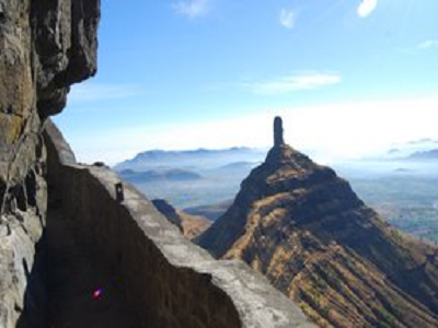
Tungi : The route from the archway, going to the right, goes to the Tungi pinnacle. One can reach the pinnacle within half an hour from the archway. The Tungi Pinnacle is taller than Mangi. To climb the pinnacle, it is very essential to have a good knowledge of rock climbing. Like Mangi, one can also go round the Tungi pinnacle. There are 3 caves on the way. There is a temple of Tungigiri in one of these caves and there are 99 carvings of Buddha in these caves.
Directions for Tungi Fort, Nashik