

- Name of the Fort:
- Hatgad
- Difficulty Level:
- Medium
- Endurance Level:
- Medium
About Fort
- Height of the Fort:
- 3600 ft
- Base Village:
- Hatgad
- District:
- Nashik
- Region:
- Nashik
- Route:
- Hatgad Fort, near Mulher and almost on the edge of the Sahyadris, stands overlooking the Surgana taluka and the southern Dangs. It occupies a flat-topped hill which rises some 183 metres (600 feet) above the plain, and about 1,097.28 metres (3,600 feet) above sea-level. At its foot lies the village of Hatgad.
- Distance from Pune:
- Description:
- Hatgad fort stands overlooking Surgana taluka from where the eastern range of Sahyadris starts called as Saatmal range. This fort is branched from the main mountain range.
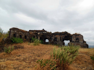
The only local story is that in the time of Rangrav Aundhekar, the last officer who held the fort for the Peshva, one Supkarna Bhil came with a large following and laid siege to the fort. The siege continued for some time and was not raised until a shot from the garrison destroyed one of the Bhil guns. The Bhils then burnt the village and withdrew. In 1818 Captain Briggs, who visited the fort, reports that it was not more than 400 feet (121.92 metres) above the plain. Like other Nasik forts it had a perpendicular scarp of rock all round, and its want of height was more than made up by the strength of its gateways and the works connected with them. It had a wall all round which, though not very thick, was sufficient to give the garrison over from everything but large guns. There were five gateways in a large tunnel which traversed the rock as it ascended by steep steps.
Directions for Hatgad Fort, Nashik