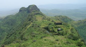


- Name of the Fort:
- Vajragad
- Difficulty Level:
- Easy
- Endurance Level:
- Easy
About Fort
- Height of the Fort:
- 4444 ft (1355 m)
- Base Village:
- Narayanpur
- District:
- Pune
- Region:
- Lonavla
- Route:
- Pune-Satara Highway-Narayanpur
- Distance from Pune:
- 40 Km
- Description:
- Vajragad was one of the 23 forts given to Mughals in Purandar treaty in 1665. It was won back in 1670. After Shivaji Maharaj's death, it was lost to Mughal and they named it as "Ajamgad". Again in 1695, Shahu Maharaj won it and handed over the control to Peshwas. It is also called "Rudramal". It's height from sea level is about 4444 ft (~1355 m). Vajragad and Purandar are sibling forts very near to Pune (about 30-35 Kms). Its mythological name is "Indraneel Parvat". As per Hindu mythology, when Lord Hanuman attempted to carry "Dronagiri" mountain range, a portion of it slipped off his hands and fell down to form "Indraneel Parvat". There is a Siva Temple in the base village of these forts, "Narayanpur", called "Narayaneshwar". This temple is said to be from the days of "Pandavas". Purandar and Vajragad always had a demanding place in Maratha Empire as Purandar was Capital of Peshwas for many years.
Directions for Vajragad Fort, Lonavla