

- Name of the Fort:
- Makarandgad
- Difficulty Level:
- Easy
- Endurance Level:
- Easy
About Fort
- Height Of the Fort:
- 1236 ft
- District:
- Satara
- Region:
- Pune
- Base Village:
- Hatlot, Chaturbet
- How To Reach:
- State transport buses are available from Mahabaleshwar to both villages at the base. For Hatlot only one bus, which goes in the evening, is available. For Chaturbet there are three buses. From Hatlot the climb is steep. It takes 1.5 hrs to climb from here. From Chaturbet the rout has gradual climb. It takes 2.5 hrs from here to reach Ghonaspur, a village at the shoulder of the fort. It takes half hour to climb the fort from here.
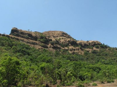
- Description:
- The fort is situated on the banks of river Koyna and covered with thick forest. The village Ghonaspur has a primary school and a Mahadev temple. There is no shielding wall to the fort. On the top of the fort there is one Bhairoba temple. Below it on the east side of the fort is old water tank (cave). Makarandgad is a fort and next to it is Madhu shikhar (peak).From the top of Makarandgad we can see the Mahabaleshwar range, Pratapgad, on west side are Sumargad, Mahipatgad and Rasalgad. The view of Koyna river and the backwater of Shivsagar dam is very pleasant.
- History:
- Madhumakarandgad has very little documented history. It was used to safeguard Pratapgad.
Directions for Makarandgad Fort, Satara